
Brazil Tourist Attractions by State reveal a country that feels more like a continent than a single destination. Across Brazil, travelers can cross Amazonian rivers, walk through colonial cities, swim beside coral reefs, explore vast wetlands, hike among sandstone plateaus, visit modernist landmarks, and hear dozens of regional accents without leaving the same nation.
Brazil consists of 26 states and the Federal District. Moreover, the Brazilian Institute of Geography and Statistics organizes these federal units into five major regions: North, Northeast, Central-West, Southeast, and South. Each region presents a different combination of climate, history, landscape, cuisine, and culture. IBGE confirms Brazil’s political and regional organization.
The country also contains 25 properties on UNESCO’s World Heritage List, including historic cities, archaeological sites, modernist urban landscapes, islands, wetlands, forests, and national parks. Therefore, a complete guide to Brazil tourist attractions by state must go far beyond Rio de Janeiro and the Amazon. UNESCO maintains the official list of Brazilian World Heritage properties.
This guide covers every Brazilian state, plus the Federal District. Along the way, it also teaches practical Brazilian Portuguese vocabulary, regional demonyms, useful questions, and natural expressions that can help visitors interact with local people.
How to Use This Brazil Tourist Attractions by State Guide
Brazil’s size makes careful planning essential. A flight from one region to another may take several hours, while some national parks require boats, four-wheel-drive vehicles, advance reservations, or accredited guides.
For that reason, each section includes:
- The state capital and regional location
- The most important natural, historical, and cultural attractions
- Practical planning advice
- A Brazilian Portuguese mini-lesson
- The correct name for someone from that state
Opening hours, admission systems, road conditions, park rules, and access permissions can change. Consequently, travelers should confirm details through official tourism agencies, environmental authorities, or attraction websites before leaving.
Essential Brazilian Portuguese Before Exploring Brazil
Portuguese serves as Brazil’s official language. Although English appears in major hotels and international attractions, many drivers, shopkeepers, guides, and restaurant employees primarily speak Portuguese.
A few phrases can transform the experience.
Basic greetings
- Olá! means “Hello!”
- Oi! means “Hi!”
- Bom dia! means “Good morning!”
- Boa tarde! means “Good afternoon!”
- Boa noite! means “Good evening” or “Good night.”
- Tudo bem? means “How are you?” or “Is everything okay?”
- Tudo ótimo! means “Everything is great!”
- Por favor means “Please.”
- Com licença means “Excuse me” when asking for space or attention.
- Desculpe means “Sorry.”
- Obrigado means “Thank you” when the speaker identifies as male.
- Obrigada means “Thank you” when the speaker identifies as female.
Importantly, the form of obrigado agrees with the speaker, not with the person receiving the thanks.
Essential sightseeing questions
- Onde fica este ponto turístico? means “Where is this tourist attraction?”
- Como eu chego lá? means “How do I get there?”
- É longe daqui? means “Is it far from here?”
- Dá para ir a pé? means “Can I walk there?”
- Que horas abre? means “What time does it open?”
- Que horas fecha? means “What time does it close?”
- Precisa comprar ingresso? means “Do I need to buy a ticket?”
- Precisa reservar com antecedência? means “Do I need to book in advance?”
- Posso tirar uma foto? means “May I take a photo?”
- Tem visita guiada? means “Is there a guided tour?”
- Tem banheiro por aqui? means “Is there a restroom nearby?”
A quick pronunciation guide
Brazilian Portuguese pronunciation varies across the country. Nevertheless, several patterns help beginners:
- ão produces a nasal sound, as in pão and São Paulo.
- nh sounds similar to the “ny” in “canyon,” as in banheiro.
- lh resembles the “lli” sound in “million,” as in Ilha.
- An initial r often sounds similar to an English “h,” although accents vary.
- In many regions, ti sounds like “chee,” while di sounds like “jee.”
- The final e in words such as Recife often sounds like “ee.”
Perfect pronunciation is unnecessary. In contrast, speaking politely and showing genuine interest usually matters far more.
North Region: Amazonian Nature and Living Cultures
The North covers an enormous part of Brazil. Forests, rivers, floodplains, savannas, Indigenous territories, waterfalls, archaeological sites, and remote communities define its tourism.
Distances can be challenging, however. In many areas, rivers function as roads, and a destination that appears close on a map may require a long boat journey.
Acre
Capital and travel profile
Rio Branco serves as Acre’s capital. The state occupies Brazil’s far west, beside Peru and Bolivia, and offers some of the country’s least commercialized Amazonian experiences.
A visitor who chooses Acre usually seeks forest landscapes, conservation history, archaeology, community tourism, and a deeper understanding of the rubber economy.
Main tourist attractions in Acre
Serra do Divisor National Park protects mountains, rivers, waterfalls, forest trails, and exceptional biodiversity near the Peruvian border. Visitors commonly enter the region through Cruzeiro do Sul and Mâncio Lima, followed by a long river journey. Because logistics remain complex, travelers should arrange transportation and accommodation with experienced local operators. ICMBio provides official information about Serra do Divisor National Park.
Xapuri connects tourism with the history of rubber tapping and environmental activism. The town’s attractions include the Chico Mendes House, the Xapuri Museum, historic streets, and nearby forest experiences.
Acre’s geoglyphs reveal large geometric earthworks created by pre-Columbian societies. Several accessible archaeological locations stand near the BR-317 highway, although visitors must respect protected boundaries and official guidance. The Acre State Government describes the state’s archaeological and cultural tourism.
Rio Branco’s historic center offers the Palácio Rio Branco, Mercado Velho, Novo Mercado Velho, Gameleira promenade, museums, and riverside landscapes. Together, these places introduce Acre’s political formation and its relationship with the rubber trade.
Brazilian Portuguese for Acre
- Floresta means “forest.”
- Seringueira means “rubber tree.”
- Seringal refers to an area where rubber trees grow or where rubber extraction traditionally occurred.
- Trilha means “trail.”
- Barco means “boat.”
Useful phrase: “Precisa de guia para fazer esta trilha?”
Translation: “Do I need a guide to hike this trail?”
A person from Acre is acreano or acreana.
Amapá
Capital and travel profile
Macapá, the capital of Amapá, sits beside the Amazon River and near the Equator. Unlike most Brazilian capitals, no highway connects it directly with the national road network, so flights and river transport play central roles.
Main tourist attractions in Amapá
Marco Zero do Equador marks the Equator in Macapá. Visitors can symbolically place one foot in each hemisphere, learn about equinoxes, and view nearby cultural spaces.
Fortaleza de São José de Macapá presents a monumental star-shaped fortification beside the Amazon River. Its walls, internal buildings, and military design introduce the colonial contest for control of the Amazon’s northern entrance.
Macapá’s riverfront includes viewpoints, public squares, markets, restaurants, and areas where visitors can watch the vast Amazon River. The city’s newer Parque Meio do Mundo also connects the Equator theme with recreation and public space. Macapá’s municipal government lists its principal attractions.
Curiaú preserves Afro-Amapá traditions in a protected environmental area near the capital. Community-based experiences may introduce visitors to local food, music, landscapes, and quilombola history.
Tumucumaque Mountains National Park protects an immense and remote section of Amazonian forest. However, this destination requires expedition-level planning, authorized access, experienced guides, and realistic expectations about infrastructure. ICMBio publishes the park’s official management information.
Brazilian Portuguese for Amapá
- Linha do Equador means “Equator.”
- Hemisfério Norte means “Northern Hemisphere.”
- Hemisfério Sul means “Southern Hemisphere.”
- Fortaleza means “fortress.”
- Orla means “waterfront.”
Useful phrase: “Estamos no Hemisfério Norte ou no Hemisfério Sul?”
Translation: “Are we in the Northern or Southern Hemisphere?”
A person from Amapá is amapaense.
Amazonas
Capital and travel profile
Manaus serves as the main gateway to the Brazilian Amazon. Nevertheless, Amazonas extends far beyond its capital and includes protected forests, vast rivers, archipelagos, Indigenous cultures, and small communities.
Main tourist attractions in Amazonas
Teatro Amazonas stands as Manaus’s most recognizable architectural landmark. Built during the rubber boom, the theater occupies Largo de São Sebastião and continues to host performances and guided visits.
Mercado Municipal Adolpho Lisboa introduces regional fruits, fish, spices, crafts, and everyday Amazonian commerce. Nearby, Manaus’s historic center also contains the port, cathedral, palaces, and renovated public spaces.
Encontro das Águas occurs where the dark Rio Negro meets the sediment-rich Rio Solimões. Differences in temperature, speed, and composition allow the waters to flow side by side before gradually mixing. Boat excursions usually leave from Manaus. Visit Brasil explains Manaus and the Meeting of the Waters.
Anavilhanas National Park protects an enormous river archipelago in the Rio Negro. Novo Airão provides a useful base for boat journeys, forest trails, wildlife observation, and community experiences.
Central Amazon Conservation Complex, which includes protected areas such as Jaú National Park, holds UNESCO World Heritage status. Its scale and biodiversity make it globally important, but access requires careful organization. UNESCO describes the Central Amazon Conservation Complex.
Presidente Figueiredo offers waterfalls, caves, forest trails, and swimming areas north of Manaus. Meanwhile, Parintins attracts cultural travelers through the Boi-Bumbá tradition and its famous annual festival.
Brazilian Portuguese for Amazonas
- Encontro das águas means “meeting of the waters.”
- Igarapé refers to a small Amazonian waterway or creek.
- Floresta alagada means “flooded forest.”
- Comunidade ribeirinha means “riverside community.”
- Porto means “port.”
Useful phrase: “Que horas sai o barco para o passeio?”
Translation: “What time does the boat leave for the tour?”
A person from Amazonas is amazonense. The word amazonas usually refers to the state, while amazônico describes something connected with the wider Amazon region.
Pará
Capital and travel profile
Pará combines the metropolis of Belém with Atlantic islands, Amazonian rivers, forest reserves, archaeological heritage, religious traditions, and freshwater beaches.
Main tourist attractions in Pará
Ver-o-Peso Market forms the cultural heart of Belém’s waterfront. Early in the morning, vendors sell fish, herbs, fruit, spices, crafts, and regional meals.
Estação das Docas converted historic port warehouses into a cultural and culinary complex. In addition, nearby attractions include Forte do Presépio, Casa das Onze Janelas, Mangal das Garças, and the historic Cidade Velha district.
Ilha do Combu sits across the river from central Belém. Community businesses offer meals, cacao experiences, forest walks, and insight into island life. Visit Brasil presents Belém’s principal cultural and culinary attractions.
Marajó Island features buffalo culture, Marajoara ceramics, beaches, wetlands, farms, and communities shaped by rivers and tides. Soure and Salvaterra serve as common bases.
Alter do Chão, near Santarém, becomes famous for freshwater beaches that emerge as river levels fall. Ilha do Amor, Lago Verde, Ponta de Pedras, and nearby forest communities create a strong combination of relaxation and ecotourism. Visit Brasil notes that the most visible beach season commonly occurs between August and December, although river conditions vary annually. See the official Alter do Chão destination guide.
Tapajós National Forest offers community-led forest experiences, giant trees, trails, and river landscapes. Travelers should book through recognized community organizations or qualified local operators.
Brazilian Portuguese for Pará
- Praia de rio means “river beach.”
- Feira means “market” or “street fair.”
- Erva means “herb.”
- Cerâmica means “ceramics.”
- Açaí paraense refers to the less-sweet local style of açaí, often served with flour and savory food.
Useful phrase: “Quero provar o açaí do jeito paraense.”
Translation: “I want to try açaí the Pará way.”
A person from Pará is paraense.
Rondônia
Capital and travel profile
Porto Velho grew around river transport and the Madeira-Mamoré Railway. Consequently, Rondônia’s strongest attractions connect Amazonian landscapes with rail history, frontier heritage, and the rivers near Bolivia.
Main tourist attractions in Rondônia
Madeira-Mamoré Railway Complex preserves locomotives, rail structures, historical objects, and memories of the difficult project that helped shape Porto Velho. The state tourism portal provides background on the railway and its importance. Rondônia Tem Turismo describes the Madeira-Mamoré Railway.
As Três Caixas d’Água, or the Three Water Tanks, have become a symbol of Porto Velho. Their elevated metal structures reflect the city’s railway period.
Memorial Rondon explores communication, territorial expeditions, and the historical legacy associated with Marshal Cândido Rondon.
Real Forte Príncipe da Beira rises beside the Guaporé River near Costa Marques. Its remote position and monumental walls make it one of Rondônia’s most significant historic sites. Still, reaching it requires serious road and transport planning. The Rondônia State Government explains its historical and tourism value.
Guajará-Mirim and the Mamoré River provide access to river landscapes, railway heritage, border culture, and the surroundings of Pacaás Novos.
Brazilian Portuguese for Rondônia
- Estrada de ferro means “railway.”
- Locomotiva means “locomotive.”
- Forte means “fort.”
- Fronteira means “border.”
- Margem do rio means “riverbank.”
Useful phrase: “Quanto tempo leva a viagem até o forte?”
Translation: “How long does the journey to the fort take?”
A person from Rondônia is rondoniense.
Roraima
Capital and travel profile
Boa Vista presents broad avenues, tropical savanna, riverfront spaces, and access to the northernmost landscapes of Brazil. Roraima differs visually from many Amazonian destinations because lavrado, a regional savanna, covers substantial areas.
Main tourist attractions in Roraima
Boa Vista’s Orla Taumanan overlooks the Rio Branco and offers walking areas, restaurants, viewpoints, and public spaces. Praça das Águas and Parque do Rio Branco add other urban stops.
Serra do Tepequém attracts visitors with table-top landscapes, waterfalls, trails, viewpoints, and the history of former mining communities. Roraima’s official tourism material identifies Paiva and Funil among its best-known waterfalls. See the Roraima tourism guide.
Viruá National Park protects a mosaic of forests, wetlands, and open vegetation near Caracaraí. Birdwatchers and researchers value its biodiversity, although visitors should confirm access arrangements with ICMBio.
Mount Roraima rises at the meeting area of Brazil, Guyana, and Venezuela. Most established summit expeditions use an approach through Venezuela. Access from Brazilian territory involves sensitive protected and Indigenous areas, so travelers must never attempt independent entry.
Community-based Indigenous tourism, where formally authorized and led by the community itself, can provide cultural learning. Permission, respect, and local control remain essential.
Brazilian Portuguese for Roraima
- Lavrado names Roraima’s characteristic savanna landscape.
- Serra means “mountain range” or “highland.”
- Cachoeira means “waterfall.”
- Mirante means “viewpoint.”
- Tempo fechado means “overcast or worsening weather.”
Useful phrase: “Como está o tempo na serra hoje?”
Translation: “How is the weather in the mountains today?”
A person from Roraima is roraimense.
Tocantins
Capital and travel profile
Palmas, Brazil’s newest planned state capital, provides the principal air gateway to Tocantins. Beyond the city, the state contains Cerrado landscapes, dunes, rivers, waterfalls, canyons, caves, and historic towns.
Main tourist attractions in Tocantins
Jalapão ranks among Brazil’s leading ecotourism regions. Its attractions include the golden dunes, Cachoeira da Velha, Cachoeira do Formiga, Pedra Furada, Cânion Sussuapara, and the famous fervedouros. These clear-water springs create enough upward pressure to help bathers float. The Tocantins State Government lists Jalapão’s main attractions.
Palmas offers Praça dos Girassóis, Palácio Araguaia, Praia da Graciosa, Lake Palmas, and views from the Serra do Lajeado.
Cantão State Park protects a transition zone between the Cerrado and Amazon. Lakes, channels, forests, and wildlife make the area important for nature observation.
Serras Gerais presents canyons, caves, turquoise rivers, waterfalls, and communities around towns such as Dianópolis, Rio da Conceição, Almas, and Aurora do Tocantins.
Natividade preserves churches, traditional houses, gold-cycle history, crafts, and religious celebrations. The town adds a valuable cultural dimension to a state often marketed mainly through nature.
Bananal Island contains ecologically and culturally sensitive territory, including Indigenous lands. Therefore, visitors must enter only places with formal authorization and community-approved tourism.
Brazilian Portuguese for Tocantins
- Fervedouro refers to a spring where upward-flowing water creates natural buoyancy.
- Duna means “dune.”
- Nascente means “spring” or “source of a river.”
- Poço means “natural pool” or “well,” depending on context.
- Estrada de terra means “dirt road.”
Useful phrase: “O fervedouro está aberto para visitação?”
Translation: “Is the fervedouro open to visitors?”
A person from Tocantins is tocantinense.
Northeast Region: Beaches, History, Music, and the Sertão
The Northeast combines long coastlines with colonial capitals, Afro-Brazilian heritage, Indigenous history, dunes, mangroves, mountain plateaus, semi-arid landscapes, archaeological sites, and major cultural festivals.
Although beach tourism dominates international advertising, the region’s interior deserves equal attention. Historic towns, national parks, canyons, craft traditions, and the sertão reveal a much broader Northeast.
Alagoas
Capital and travel profile
Maceió gives travelers immediate access to green-blue water, reefs, urban beaches, crafts, and seafood. Meanwhile, short road journeys lead to quieter coastlines and historic towns.
Main tourist attractions in Alagoas
Pajuçara and Ponta Verde form the center of Maceió’s beach tourism. At low tide, traditional jangadas carry visitors toward offshore natural pools. However, marine conditions and tide levels determine whether tours can operate.
Pontal da Barra brings together lagoon views, colorful streets, workshops, and the celebrated bordado filé, a regional embroidery tradition.
Maragogi attracts travelers through its natural pools, locally called galés, as well as beaches such as Antunes and Barra Grande. Visitors should consult tide tables and choose authorized operators.
São Miguel dos Milagres, Porto de Pedras, and Praia do Patacho form part of Alagoas’s quieter Ecological Route. Coconut groves, small inns, communities, and beaches create a slower alternative to Maceió and Maragogi.
Praia do Gunga combines the Atlantic Ocean, Lagoa do Roteiro, coconut plantations, and colorful cliffs. Farther inland, Piranhas provides a historic base for excursions through the São Francisco River region and Xingó Canyon.
Marechal Deodoro and Penedo preserve churches, civic buildings, cultural institutions, and colonial streets. Together, they show that Alagoas offers more than beach tourism. Visit Brasil provides an extensive official guide to Maceió and nearby attractions.
Brazilian Portuguese for Alagoas
- Piscina natural means “natural pool.”
- Maré baixa means “low tide.”
- Maré alta means “high tide.”
- Jangada means “traditional raft.”
- Rendeira means “lace maker.”
Useful phrase: “A maré está baixa agora?”
Translation: “Is the tide low now?”
A person from Alagoas is alagoano or alagoana.
Bahia
Capital and travel profile
Bahia unites Afro-Brazilian culture, colonial architecture, religious traditions, long coastlines, islands, cacao landscapes, forests, mountains, caves, waterfalls, and historic communities.
Main tourist attractions in Bahia
Salvador’s Historic Center and Pelourinho preserve colorful buildings, churches, public squares, museums, music, capoeira, and Afro-Brazilian institutions. UNESCO inscribed the historic center in 1985. Nearby landmarks include Elevador Lacerda, Mercado Modelo, Igreja de São Francisco, and the waterfront at Barra. Visit Brasil presents Salvador’s history and Afro-Brazilian heritage.
Chapada Diamantina offers mountains, caves, waterfalls, valleys, natural pools, and former mining towns. Lençóis works as the most established base, while Vale do Capão, Mucugê, Andaraí, Igatu, and Ibicoara open different parts of the region. Visit Brasil describes Chapada Diamantina’s main outdoor experiences.
Porto Seguro, Arraial d’Ajuda, Trancoso, and Caraíva combine beaches with Indigenous history, colonial heritage, village centers, and Atlantic Forest landscapes.
Morro de São Paulo and Boipeba offer car-free or low-traffic island experiences, beaches, mangroves, viewpoints, and boat routes in the Tinharé archipelago.
Itacaré and Ilhéus connect cacao history with forests, beaches, rivers, and regional literature. In contrast, Praia do Forte combines natural pools, a walkable village, historic ruins, and marine conservation initiatives.
Abrolhos protects reefs and islands off the southern Bahia coast. Boat access requires reputable operators, suitable weather, and compliance with marine park rules.
The Bahia State Tourism Department regularly identifies Salvador, Porto Seguro, Morro de São Paulo, Itacaré, and Chapada Diamantina among the state’s leading destinations. See Bahia’s official tourism overview.
Brazilian Portuguese for Bahia
- Acarajé names a traditional Afro-Brazilian food associated especially with Bahia.
- Terreiro may refer to a sacred community space in Afro-Brazilian religions.
- Pelourinho is the name of Salvador’s famous historic district.
- Ladeira means “steep street” or “slope.”
- Fita do Bonfim means “Bonfim ribbon.”
Useful phrase: “Com licença, posso tirar uma foto?”
Translation: “Excuse me, may I take a photo?”
A person from Bahia is baiano or baiana.
Ceará
Capital and travel profile
Fortaleza anchors Ceará’s tourism, but the state stretches from urban beaches to fishing villages, dune fields, mountain environments, religious centers, and the fossil-rich Cariri.
Main tourist attractions in Ceará
Fortaleza offers Praia do Futuro, the Beira-Mar promenade, Mercado Central, Centro Dragão do Mar de Arte e Cultura, Theatro José de Alencar, museums, and craft markets. Visit Brasil describes Fortaleza’s beaches and cultural attractions.
Jericoacoara combines dunes, lagoons, mangroves, sandy streets, Pedra Furada, and sunset views. Jijoca, Preá, and the protected national park form part of the wider destination. Because vehicles cross sandy terrain, visitors should use authorized transfers. Visit Brasil provides the official Jericoacoara destination guide.
Canoa Quebrada features reddish cliffs, a long beach, dune landscapes, and the village’s central Broadway street.
Beach Park and Porto das Dunas, near Fortaleza, attract families seeking organized recreation. Farther along the coast, Flecheiras, Icaraizinho de Amontada, and Mundaú provide alternatives with smaller communities.
Juazeiro do Norte serves as one of Brazil’s major religious tourism centers. The wider Cariri region also offers museums, cultural traditions, geological sites, and the Araripe landscapes.
Serra da Ibiapaba, including Ubajara, presents caves, forest trails, viewpoints, waterfalls, and a cooler highland climate.
Brazilian Portuguese for Ceará
- Barraca de praia usually means a permanent beachfront restaurant or service structure, not merely a tent.
- Duna means “dune.”
- Falésia means “cliff.”
- Rede means “hammock” or “network,” depending on context.
- Arretado can mean impressive, intense, or excellent in informal Northeastern speech, depending on tone.
Useful phrase: “Onde fica a barraca de praia?”
Translation: “Where is the beach restaurant?”
A person from Ceará is cearense.
Maranhão
Capital and travel profile
Maranhão occupies a fascinating transition between the Amazon, Cerrado, and Northeastern coast. Its attractions include tiled colonial buildings, dune fields, seasonal lagoons, mangroves, river beaches, and sandstone plateaus.
Main tourist attractions in Maranhão
São Luís Historic Center contains thousands of buildings, many decorated with Portuguese tiles. Palácio dos Leões, Rua do Giz, museums, churches, markets, and cultural houses introduce the city’s heritage. UNESCO inscribed the center in 1997. Visit Brasil explains São Luís’s World Heritage architecture.
Lençóis Maranhenses National Park creates an extraordinary landscape of white dunes and seasonal freshwater lagoons. Barreirinhas, Santo Amaro, and Atins provide different entry points. Lagoon conditions change with rainfall, so visitors should research the season before reserving. UNESCO added the national park to the World Heritage List in 2024. UNESCO describes Lençóis Maranhenses National Park.
Alcântara preserves ruins, churches, mansions, squares, and Afro-Brazilian communities across the bay from São Luís. Boat schedules depend on tides and weather.
Chapada das Mesas surrounds Carolina and Riachão with waterfalls, plateaus, trails, rivers, and natural pools. Poço Azul, Encanto Azul, and the national park rank among its major attractions. Visit Brasil presents the Chapada das Mesas region.
Tutóia and the Delta region combine dunes, islands, mangroves, and waterways. Together with Lençóis Maranhenses and the Piauí and Ceará coasts, the area forms part of the Route of Emotions.
Brazilian Portuguese for Maranhão
- Lençóis literally means “bedsheets,” a reference to the visual appearance of the dunes.
- Lagoa cheia means “full lagoon.”
- Azulejo means “decorative tile.”
- Casarão means “large historic house.”
- Bumba meu boi names an important cultural tradition involving theater, music, dance, crafts, and community identity.
Useful phrase: “As lagoas estão cheias nesta época?”
Translation: “Are the lagoons full at this time of year?”
A person from Maranhão is maranhense.
Paraíba
Capital and travel profile
João Pessoa offers beaches, green spaces, history, and an accessible urban scale. Beyond the capital, Paraíba includes dramatic coastal cliffs, archaeological sites, mountain towns, and the cultural center of Campina Grande.
Main tourist attractions in Paraíba
João Pessoa’s historic center includes churches, convents, squares, cultural centers, and architecture from different periods. The Centro Cultural São Francisco stands among its most impressive complexes.
Cabo Branco and Ponta do Seixas mark Brazil’s far eastern coastline. The lighthouse, cliffs, viewpoints, and nearby cultural institutions create one of the capital’s classic routes.
Picãozinho and Seixas natural pools attract boat excursions when tide and marine conditions permit. Therefore, travelers should verify departure times rather than assuming daily access.
Praia do Jacaré sits beside the Paraíba River and draws visitors for sunset. Meanwhile, the southern coast around Conde offers Coqueirinho, Tabatinga, Tambaba, and other beaches framed by cliffs and vegetation.
Campina Grande becomes nationally prominent during its São João celebrations. At other times, museums, markets, regional food, and cultural venues still justify a visit.
Areia preserves historic buildings, museums, theaters, sugar-mill heritage, and highland scenery. Farther inland, the Ingá Stone displays extensive rock inscriptions beside the Ingá River.
The Ministry of Tourism highlights João Pessoa, Picãozinho, Coqueirinho, and Campina Grande among Paraíba’s leading tourism images. See the official federal tourism source.
Brazilian Portuguese for Paraíba
- Pôr do sol means “sunset.”
- Litoral sul means “southern coast.”
- Centro histórico means “historic center.”
- Festa junina means “June festival.”
- Forró names a group of Northeastern musical and dance traditions.
Useful phrase: “Qual é o melhor lugar para ver o pôr do sol?”
Translation: “What is the best place to watch the sunset?”
A person from Paraíba is paraibano or paraibana.
Pernambuco
Capital and travel profile
Pernambuco combines Recife’s urban culture, Olinda’s colonial streets, coral-protected beaches, the Agreste interior, São Francisco River landscapes, and the Atlantic islands of Fernando de Noronha.
Main tourist attractions in Pernambuco
Recife Antigo centers on Marco Zero, Rua do Bom Jesus, museums, cultural spaces, bridges, and waterfront architecture. Other notable stops include Paço do Frevo, Cais do Sertão, Casa da Cultura, Instituto Ricardo Brennand, and Oficina Francisco Brennand. Visit Brasil introduces Recife’s history, rivers, and cultural attractions.
Olinda rises on hills north of Recife. Colorful houses, churches, convents, workshops, viewpoints, and Carnival traditions fill its UNESCO-listed historic center.
Porto de Galinhas features natural pools, reefs, coconut-lined beaches, shops, and accommodation around Ipojuca. Maracaípe and Muro Alto expand the coastal itinerary. Visit Brasil describes Porto de Galinhas.
Fernando de Noronha protects volcanic landscapes, marine biodiversity, viewpoints, and beaches such as Baía do Sancho, Baía dos Porcos, and Cacimba do Padre. Environmental fees, park admission, trail reservations, and access rules require advance research. Visit Brasil maintains an official Fernando de Noronha guide.
Caruaru represents the cultural and commercial heart of the Agreste. Its market, crafts, clay art, regional food, and São João celebrations attract visitors year-round.
Petrolina and the São Francisco Valley offer riverfront landscapes, islands, agricultural experiences, and routes connecting Pernambuco with neighboring Bahia.
Brazilian Portuguese for Pernambuco
- Frevo names a fast musical and dance tradition strongly connected with Pernambuco.
- Sombrinha means “small umbrella,” an iconic element in frevo imagery.
- Marco Zero means “zero point” or the reference point from which distances begin.
- Arrecife means “reef.”
- Mangue means “mangrove.”
Useful phrase: “Onde começa a visita ao centro histórico?”
Translation: “Where does the historic-center tour begin?”
A person from Pernambuco is pernambucano or pernambucana.
Piauí
Capital and travel profile
Piauí offers one of Brazil’s most important archaeological landscapes, a small but attractive coastline, a major river delta, unusual sandstone formations, and the inland capital of Teresina.
Main tourist attractions in Piauí
Serra da Capivara National Park protects rock shelters, archaeological sites, canyons, trails, and extensive rock art. São Raimundo Nonato provides museums, accommodation, and access to the park. UNESCO inscribed Serra da Capivara in 1991. UNESCO explains its cultural significance.
Parnaíba Delta divides into islands, channels, mangroves, dunes, and coastal environments before reaching the Atlantic. Parnaíba and Ilha Grande serve as common gateways.
Sete Cidades National Park contains sandstone formations, trails, vegetation from different ecosystems, and archaeological sites. Visitors commonly explore organized circuits with guides. ICMBio publishes the park’s official management information.
Barra Grande offers a beach village, mangroves, nature excursions, and strong coastal winds. Nearby communities provide additional routes along Piauí’s short coastline. Visit Brasil presents Barra Grande and the Delta region.
Teresina sits where the Poti and Parnaíba rivers meet. Parque Ambiental Encontro dos Rios, craft centers, museums, parks, and regional food provide reasons to explore the capital. Visit Brasil describes Teresina’s river culture.
Brazilian Portuguese for Piauí
- Pintura rupestre means “rock painting.”
- Sítio arqueológico means “archaeological site.”
- Delta has the same basic meaning in Portuguese and English.
- Condutor means “local visitor guide” in many protected areas.
- Formação rochosa means “rock formation.”
Useful phrase: “Tem um condutor credenciado disponível?”
Translation: “Is an accredited local guide available?”
A person from Piauí is piauiense.
Rio Grande do Norte
Capital and travel profile
Rio Grande do Norte attracts visitors through dunes, cliffs, reefs, lagoons, beaches, historic forts, and coastal villages. Natal provides the largest transport hub.
Main tourist attractions in Rio Grande do Norte
Natal offers Ponta Negra, views of Morro do Careca, the Via Costeira, local craft centers, and the Potengi River. Travelers should respect current protection rules around the dune.
Forte dos Reis Magos stands near the entrance of the Potengi River and introduces the colonial history of Natal.
Genipabu combines dunes, lagoon landscapes, and coastal views north of the capital. Visitors who choose vehicle excursions should hire licensed operators and request a calm, safety-focused itinerary.
Pipa, in Tibau do Sul, features cliffs, beaches, viewpoints, trails, and a busy village center. Baía dos Golfinhos and Praia do Madeiro rank among the surrounding attractions, although wildlife sightings never come with guarantees. Visit Brasil presents Pipa’s beaches and natural areas.
São Miguel do Gostoso, Touros, and Galinhos offer smaller coastal destinations with strong winds, broad beaches, and relaxed village settings.
Maracajaú attracts visitors through reefs and offshore natural pools. Once again, marine conditions determine the schedule.
The state tourism agency identifies Natal, Pipa, Genipabu, and São Miguel do Gostoso among Rio Grande do Norte’s established destinations. See EMPROTUR’s official overview.
Brazilian Portuguese for Rio Grande do Norte
- Dromedário means “dromedary,” an animal associated with some Genipabu tourism imagery.
- Passeio de buggy means “buggy tour.”
- Sem emoção literally means “without excitement,” but on a dune tour it requests the calmer option.
- Com segurança means “safely.”
- Protetor solar means “sunscreen.”
Useful phrase: “Quero o passeio tranquilo e com segurança, por favor.”
Translation: “I want the calm and safe tour, please.”
A person from Rio Grande do Norte is potiguar. This distinctive demonym comes from a Tupi term traditionally connected with shrimp eating.
Sergipe
Capital and travel profile
Sergipe may be Brazil’s smallest state by area, but it combines an organized capital, historic towns, beaches, mangroves, river islands, and the dramatic Xingó region.
Main tourist attractions in Sergipe
Aracaju’s Orla de Atalaia offers a long promenade, public recreation areas, craft markets, restaurants, and access to the city’s main beach zone.
Museu da Gente Sergipana presents local identity through interactive exhibits about language, food, festivals, geography, and traditions.
São Cristóvão preserves colonial streets, churches, museums, and São Francisco Square, which UNESCO inscribed in 2010. UNESCO describes São Francisco Square.
Laranjeiras contributes churches, historic buildings, museums, caves, and Afro-Brazilian cultural traditions.
Xingó Canyon, near Canindé de São Francisco, features reddish rock walls and the waters of the São Francisco River. Boat trips usually operate from organized departure points, while nearby sites explore the region’s archaeology and history.
Cânion do Xingó, São Cristóvão, Laranjeiras, and Aracaju’s beaches rank among the attractions promoted by the state tourism authorities. See the Government of Sergipe’s tourism summary.
Crôa do Goré and Ilha dos Namorados offer river excursions through the Vaza-Barris estuary. Farther south, Praia do Saco presents dunes and calm coastal scenery.
Brazilian Portuguese for Sergipe
- Cânion means “canyon.”
- Velho Chico is an affectionate nickname for the São Francisco River.
- Crôa refers locally to a sandbar that appears with the tide.
- Praça means “square.”
- Patrimônio histórico means “historic heritage.”
Useful phrase: “De onde sai o barco para o cânion?”
Translation: “Where does the boat to the canyon leave from?”
A person from Sergipe is sergipano or sergipana.
Central-West Region: Cerrado, Pantanal, and Modern Brazil
The Central-West contains the federal capital, vast agricultural plateaus, the Cerrado biome, clear rivers, caves, hot springs, dramatic chapadas, and the Pantanal.
Rainfall strongly influences access. During the wet season, some roads become difficult; during the dry season, dust, heat, and fire risk require attention.
Federal District
Capital and travel profile
Brasília serves as both Brazil’s national capital and the administrative center of the Federal District. Although the Federal District is not a state, every complete Brazil tourist attractions by state guide should include it.
Main tourist attractions in the Federal District
Eixo Monumental concentrates Brasília’s most famous civic and architectural landmarks. Congresso Nacional, Palácio do Planalto, Supremo Tribunal Federal, and Praça dos Três Poderes form the political heart of the capital.
Catedral Metropolitana creates one of Brasília’s most recognizable interiors and exterior silhouettes. Nearby, the Museu Nacional and Biblioteca Nacional continue the monumental route.
Santuário Dom Bosco becomes memorable through its blue stained-glass interior, while Igrejinha Nossa Senhora de Fátima shows another scale of modernist religious design.
Memorial JK explores the life of President Juscelino Kubitschek and the construction of Brasília.
Lake Paranoá supports waterfront parks, restaurants, recreation, and views of the city’s bridges. Pontão do Lago Sul offers one of the easiest places to experience the lakeside setting.
Brasília National Park, commonly associated with the Água Mineral recreation area, protects Cerrado vegetation and important water sources.
UNESCO inscribed Brasília in 1987 because of its urban plan and modernist architecture. Visit Brasil outlines the capital’s major monuments, while UNESCO explains Brasília’s World Heritage status.
Brazilian Portuguese for Brasília
- Esplanada means “esplanade.”
- Congresso Nacional means “National Congress.”
- Palácio means “palace.”
- Superquadra refers to Brasília’s planned residential blocks.
- Eixo means “axis.”
Useful phrase: “A visita ao palácio precisa de agendamento?”
Translation: “Does the palace visit require a reservation?”
A person from Brasília or the Federal District is brasiliense. By contrast, brasileiro means a Brazilian person.
Goiás
Capital and travel profile
Goiânia provides the state’s main urban hub, while Goiás’s strongest tourism identity comes from the Cerrado, historic towns, waterfalls, caves, and hot-water resorts.
Main tourist attractions in Goiás
Chapada dos Veadeiros surrounds Alto Paraíso, Vila de São Jorge, and Cavalcante with waterfalls, canyons, quartz-rich landscapes, trails, and protected Cerrado. Major attractions include the national park, Vale da Lua, Catarata dos Couros, Cachoeira Santa Bárbara, and Mirante da Janela. Goiás Tourism provides an official overview.
City of Goiás, often called Goiás Velho, preserves colonial streets, churches, museums, bridges, and the literary legacy of Cora Coralina. UNESCO inscribed its historic center in 2001.
Pirenópolis combines colonial architecture, waterfalls, craft shops, festivals, and a walkable historic center.
Caldas Novas and Rio Quente form one of Brazil’s most established thermal-water tourism regions. Hotels, parks, and recreation complexes serve families and resort travelers.
Terra Ronca State Park protects an extraordinary network of caves and limestone landscapes. Visitors need appropriate guides and must respect weather conditions, especially during periods of heavy rain.
Goiânia contributes Art Deco architecture, parks, markets, museums, and a strong food culture. Therefore, the capital works well as more than a transport stop.
Brazilian Portuguese for Goiás
- Água quente means “hot water.”
- Caverna means “cave.”
- Gruta also means “cave” or “grotto.”
- Cachoeira means “waterfall.”
- Cidade histórica means “historic town.”
Useful phrase: “Essa cachoeira fica longe da cidade?”
Translation: “Is this waterfall far from town?”
A person from Goiás is goiano or goiana.
Mato Grosso
Capital and travel profile
Mato Grosso contains three major biomes: the Amazon, Cerrado, and Pantanal. As a result, the state offers exceptional ecological variety.
Main tourist attractions in Mato Grosso
Cuiabá’s historic center contains churches, museums, squares, markets, and preserved architecture. Mãe Bonifácia Park adds accessible Cerrado vegetation inside the city. Visit Brasil presents Cuiabá’s cultural and ecological attractions.
Chapada dos Guimarães National Park features cliffs, plateaus, caves, waterfalls, trails, and Cerrado landscapes. Véu de Noiva remains its most famous viewpoint, although trail and road access can change.
Northern Pantanal commonly uses Poconé and the Transpantaneira road as gateways. Wildlife observation, wetland landscapes, rivers, ranch stays, and photographic excursions form the main experiences.
Nobres and Bom Jardim offer clear-water floating, lagoons, waterfalls, caves, and wildlife observation. The atmosphere remains less urbanized than Bonito in neighboring Mato Grosso do Sul.
Cáceres opens another route into the Pantanal through the Paraguay River. In contrast, Vila Bela da Santíssima Trindade combines colonial history, Afro-Brazilian culture, waterfalls, and the Serra de Ricardo Franco.
Jaciara attracts outdoor travelers through rivers, waterfalls, and organized nature activities.
Mato Grosso’s tourism department consistently identifies Pantanal, Chapada dos Guimarães, and Nobres among the state’s preferred ecotourism destinations. See the state’s official tourism source.
Brazilian Portuguese for Mato Grosso
- Chapada means a high plateau or tableland region.
- Onça-pintada means “jaguar.”
- Observação de animais means “wildlife observation.”
- Estrada-parque means “park road.”
- Planície alagável means “floodplain.”
Useful phrase: “Dá para observar animais daqui sem incomodá-los?”
Translation: “Can we observe animals from here without disturbing them?”
A person from Mato Grosso is mato-grossense.
Mato Grosso do Sul
Capital and travel profile
Mato Grosso do Sul combines the southern Pantanal with clear-water rivers, caves, waterfalls, Indigenous cultures, and the Serra da Bodoquena.
Main tourist attractions in Mato Grosso do Sul
Bonito ranks among Brazil’s best-organized ecotourism destinations. Floating excursions in the Rio da Prata and Rio Sucuri, Gruta do Lago Azul, waterfalls, forest trails, and Buraco das Araras form the principal circuit. Many attractions limit daily attendance and require reservations through authorized sellers. Visit Brasil explains Bonito’s environmental tourism model.
Serra da Bodoquena National Park protects forests, limestone landscapes, rivers, and waterfalls. Bodoquena, Jardim, and Bonito provide different approaches to the wider region.
Southern Pantanal uses Corumbá, Miranda, Aquidauana, and rural properties as access points. Seasonal flooding changes both scenery and transportation.
Corumbá adds historic buildings, riverfront views, museums, and the cultural life of the Paraguay River.
Campo Grande offers Parque das Nações Indígenas, Museu das Culturas Dom Bosco, Feira Central, Mercadão, and a diverse food scene shaped by Indigenous, Japanese, Paraguayan, and Bolivian influences. Visit Brasil describes Campo Grande’s main attractions.
The state tourism foundation divides Mato Grosso do Sul into destinations that include Pantanal and Bonito-Serra da Bodoquena. Its English-language regional guide provides official planning information.
Brazilian Portuguese for Mato Grosso do Sul
- Flutuação means a guided floating or snorkeling excursion.
- Colete salva-vidas means “life jacket.”
- Rio de águas cristalinas means “crystal-clear river.”
- Gruta means “cave.”
- Tereré is a cold yerba mate drink associated with regional social life.
Useful phrase: “A flutuação inclui colete salva-vidas?”
Translation: “Does the floating excursion include a life jacket?”
A person from Mato Grosso do Sul is sul-mato-grossense.
Southeast Region: Iconic Cities, Mountains, and Atlantic Coast
The Southeast contains Brazil’s largest metropolitan centers, several famous colonial towns, Atlantic Forest reserves, mountain routes, islands, beaches, museums, and major architectural landmarks.
Even so, the region should not be reduced to Rio de Janeiro and São Paulo. Espírito Santo and Minas Gerais provide some of the Southeast’s richest food, nature, and heritage experiences.
Espírito Santo
Capital and travel profile
Vitória occupies an island and sections of the mainland, while neighboring Vila Velha holds some of the metropolitan region’s most recognizable attractions. Mountains rise a relatively short distance from the coast.
Main tourist attractions in Espírito Santo
Convento da Penha, in Vila Velha, stands on a forested hill with broad views of the coastline, Vitória, and surrounding municipalities. The religious complex ranks among the state’s strongest symbols.
Vitória offers the historic center, Palácio Anchieta, Catedral Metropolitana, Parque Pedra da Cebola, Ilha das Caieiras, and waterfront neighborhoods.
Guarapari attracts beach travelers with coves, urban beaches, marine landscapes, and access to the southern coast.
Pedra Azul State Park protects a striking granite formation, Atlantic Forest, trails, and natural pools in Domingos Martins. Because the park uses an advance booking system and periodically changes access during maintenance, visitors should consult the official page. IEMA publishes current Pedra Azul visitation rules.
Domingos Martins and the Montanhas Capixabas combine cooler weather, immigrant heritage, rural accommodation, food routes, mountains, and viewpoints.
Itaúnas State Park protects dunes, beaches, wetlands, archaeological sites, and the Itaúnas River. The village also maintains a strong connection with traditional forró culture. IEMA provides official visitor information for Itaúnas.
Santa Teresa contributes museums, historic houses, mountain scenery, and the scientific legacy of naturalist Augusto Ruschi.
Brazilian Portuguese for Espírito Santo
- Moqueca capixaba names Espírito Santo’s distinctive fish stew.
- Panela de barro means “clay pot.”
- Convento means “convent.”
- Montanha means “mountain.”
- Agendamento means “reservation” or “scheduled appointment.”
Useful phrase: “A trilha precisa de agendamento?”
Translation: “Does the trail require a reservation?”
A person from Espírito Santo is capixaba.
Minas Gerais
Capital and travel profile
Minas Gerais offers one of Brazil’s richest combinations of colonial heritage, mountain scenery, contemporary art, traditional food, caves, waterfalls, and small-town culture.
Main tourist attractions in Minas Gerais
Ouro Preto preserves sloping streets, baroque churches, museums, former mines, university traditions, and architecture from the gold cycle. UNESCO made it Brazil’s first World Heritage property in 1980.
Mariana complements Ouro Preto through colonial squares, churches, museums, and mining history.
Belo Horizonte offers Praça da Liberdade, Mercado Central, museums, cultural centers, and an active food scene. The nearby Pampulha Modern Ensemble, designed around an artificial lake, holds UNESCO status. Visit Brasil introduces Belo Horizonte and the historic cities.
Inhotim, in Brumadinho, combines large-scale contemporary art with botanical collections and landscaped gardens. Its size rewards a full-day or multi-day visit.
Tiradentes and São João del-Rei offer preserved architecture, churches, workshops, museums, and a historic railway connection when operating.
Diamantina presents stone streets, colonial buildings, music traditions, mountain views, and another UNESCO-listed historic center.
Capitólio and Furnas Lake attract visitors through canyons, viewpoints, waterfalls, and boat routes. Meanwhile, Serra da Canastra offers mountain landscapes, the São Francisco River’s headwaters, waterfalls, and rural food traditions.
Peruaçu River Canyon contains caves, rock formations, archaeological sites, and monumental natural chambers in northern Minas Gerais. UNESCO added the property to the World Heritage List in 2025. UNESCO lists Peruaçu among Brazil’s World Heritage properties.
Brazilian Portuguese for Minas Gerais
- Uai is a flexible Mineiro interjection that may express surprise, emphasis, doubt, or simple conversational rhythm.
- Trem literally means “train,” but informal Mineiro speech may use it for almost any object or situation.
- Queijo means “cheese.”
- Igreja barroca means “baroque church.”
- Cidade colonial means “colonial town.”
Useful expression: “Uai, que lugar bonito!”
Translation: “Wow, what a beautiful place!”
A person from Minas Gerais is mineiro or mineira.
Rio de Janeiro
Capital and travel profile
Rio de Janeiro state combines one of the world’s most recognizable cities with imperial history, mountain parks, colonial towns, islands, fishing communities, and resort destinations.
Main tourist attractions in Rio de Janeiro
Christ the Redeemer and Corcovado provide panoramic views across Rio’s mountains, bays, beaches, and urban neighborhoods.
Sugarloaf Mountain offers another defining perspective through its cable-car route. In Portuguese, visitors call the cable car the bondinho.
Copacabana, Ipanema, Leblon, and Barra da Tijuca present distinct beach environments. Meanwhile, Tijuca National Park, Jardim Botânico, Parque Lage, Santa Teresa, Lapa, and the historic center broaden the city beyond its coastline. Visit Brasil provides an official Rio de Janeiro destination guide.
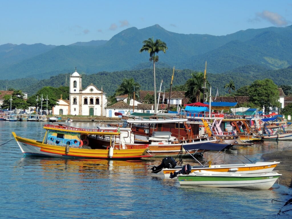
Paraty preserves colonial streets between forested mountains and an island-filled bay. Boat routes, waterfalls, cultural events, and traditional communities surround the town. Visit Brasil describes Paraty’s natural and cultural attractions.
Ilha Grande offers forest trails, beaches, boat journeys, and villages without a conventional road network. Together, Paraty and Ilha Grande form a mixed UNESCO World Heritage property that recognizes both culture and biodiversity.
Búzios combines beaches, coastal walks, boat excursions, and a lively town center. In contrast, Petrópolis focuses on imperial history, mountain architecture, museums, and cooler weather.
Serra dos Órgãos and Itatiaia national parks offer hiking, mountain views, waterfalls, and Atlantic Forest environments. Trail conditions and entry systems require advance checks.
Brazilian Portuguese for Rio de Janeiro
- Bondinho means “small tram” or “cable car,” depending on the attraction.
- Calçadão means “wide pedestrian promenade.”
- Morro means “hill.”
- Baía means “bay.”
- Carioca describes someone or something from the city of Rio de Janeiro.
Useful phrase: “Onde eu pego o bondinho?”
Translation: “Where do I take the cable car?”
A person from Rio de Janeiro state is fluminense. A person from Rio de Janeiro city is carioca.
São Paulo
Capital and travel profile
São Paulo state combines Latin America’s largest metropolitan environment with beaches, Atlantic Forest, caves, religious destinations, mountain resorts, coffee heritage, and historic port cities.
Main tourist attractions in São Paulo
São Paulo city rewards travelers interested in art, food, architecture, neighborhoods, music, museums, and urban culture. MASP, Pinacoteca, Museu da Língua Portuguesa, Museu do Ipiranga, Ibirapuera Park, Avenida Paulista, Mercado Municipal, Liberdade, and the historic center form the core itinerary. Visit Brasil presents São Paulo’s principal attractions.
Santos combines beach gardens, port history, the historic center, Museu do Café, football heritage, and the Monte Serrat viewpoint.
Ilhabela offers beaches, waterfalls, Atlantic Forest trails, and boat routes. Because biting insects can be intense, visitors usually carry appropriate protection.
Ubatuba features a long coastline, forest trails, small bays, and access toward Serra do Mar landscapes.
Aparecida attracts religious visitors through the National Sanctuary and related cultural institutions.
Campos do Jordão provides mountain scenery, parks, architecture, and cooler temperatures in the Serra da Mantiqueira.
PETAR, the Alto Ribeira Tourist State Park, protects caves, forests, rivers, and trails around Iporanga and Apiaí. Visitors need authorized guides for many cave routes.
Brotas offers river landscapes, waterfalls, and organized outdoor tourism. Meanwhile, coffee farms and historic towns across the interior introduce another side of the state.
Brazilian Portuguese for São Paulo
- Metrô means “subway.”
- Estação means “station.”
- Bairro means “neighborhood.”
- Avenida means “avenue.”
- Trânsito means “traffic.”
Useful phrase: “Dá para ir de metrô?”
Translation: “Can I get there by subway?”
A person from São Paulo state is paulista. Someone from São Paulo city is paulistano or paulistana.
South Region: Waterfalls, Canyons, Highlands, and Beaches
Brazil’s South features subtropical forests, araucaria trees, dramatic canyons, cold highlands, historic missions, planned cities, Atlantic beaches, immigrant heritage, and the Iguaçu Falls.
Temperatures change more noticeably than in much of Brazil. Therefore, travelers should pack for the specific destination and season rather than assuming consistently tropical weather.
Paraná
Capital and travel profile
Paraná combines Curitiba’s parks and architecture with Atlantic Forest, islands, canyons, historic railways, unusual rock formations, and the globally famous Iguaçu Falls.
Main tourist attractions in Paraná
Iguaçu National Park protects the Brazilian side of the Iguaçu Falls. Walkways reveal panoramic views across hundreds of cascades, while the surrounding forest protects extensive biodiversity. UNESCO inscribed the park in 1986. Visit Brasil provides practical destination information for Foz do Iguaçu.
Foz do Iguaçu also offers Parque das Aves, the meeting area of Brazil, Argentina, and Paraguay, cultural institutions, and visits connected with the Itaipu hydroelectric complex.
Curitiba features Jardim Botânico, Museu Oscar Niemeyer, Ópera de Arame, Parque Tanguá, Parque Barigui, Largo da Ordem, and a tourism bus that links major attractions. The city’s tourism institute identifies Jardim Botânico, Ópera de Arame, Museu Oscar Niemeyer, and Parque Tanguá among its best-known stops. See Curitiba’s official tourism source.
Ilha do Mel offers beaches, trails, a lighthouse, historic fortifications, and protected natural areas. Vehicle restrictions preserve its pedestrian character.
Vila Velha State Park presents sandstone formations, natural depressions, trails, and broad plateau landscapes near Ponta Grossa.
Morretes and Antonina preserve historic architecture and Serra do Mar scenery. A scenic railway journey between Curitiba and the coast, when operating, provides dramatic forest and mountain views.
Brazilian Portuguese for Paraná
- Cataratas means “large waterfalls” or “falls.”
- Garganta do Diabo means “Devil’s Throat,” the name of the falls’ most powerful section.
- Jardim Botânico means “Botanical Garden.”
- Ilha means “island.”
- Serra do Mar means “Coastal Mountain Range.”
Useful phrase: “Qual mirante tem a melhor vista das cataratas?”
Translation: “Which viewpoint has the best view of the falls?”
A person from Paraná is paranaense.
Rio Grande do Sul
Capital and travel profile
Rio Grande do Sul offers pampas, highland canyons, historic missions, urban culture, coastal environments, Italian-Brazilian and German-Brazilian heritage, and strong gaúcho traditions.
Main tourist attractions in Rio Grande do Sul
Porto Alegre offers the Guaíba waterfront, Mercado Público, Casa de Cultura Mario Quintana, museums, historic buildings, Farroupilha Park, and memorable sunset views. Visit Brasil presents Porto Alegre and its main cultural attractions.
Gramado and Canela form the center of Serra Gaúcha tourism. Gramado offers Lago Negro, Rua Coberta, gardens, chocolate traditions, events, and family attractions. Canela adds Catedral de Pedra, parks, forest scenery, and Cascata do Caracol. Visit Brasil provides an official Gramado guide.
Bento Gonçalves and Garibaldi introduce visitors to Italian-Brazilian settlement history, vineyard landscapes, historic rail heritage, rural properties, and regional cuisine.
São Miguel das Missões preserves major ruins from the Jesuit-Guarani mission system. A museum, archaeological remains, and interpretive experiences place the site within a wider history shared with Argentina and Paraguay. UNESCO recognizes the ruins as part of a transnational World Heritage property.
Cambará do Sul provides access to the Itaimbezinho and Fortaleza canyons. Trails, cliffs, waterfalls, grasslands, and changing clouds create some of southern Brazil’s most dramatic landscapes. Visit Brasil describes Cambará do Sul and the canyon region.
Pelotas offers preserved mansions, squares, museums, architecture, and a celebrated sweets tradition. Farther west, the pampas around Bagé and Santana do Livramento reveal ranching landscapes and border culture.
Brazilian Portuguese for Rio Grande do Sul
- Bah! is a common gaúcho interjection expressing surprise, admiration, frustration, or emphasis.
- Guri means “boy.”
- Guria means “girl.”
- Chimarrão is hot yerba mate traditionally shared in a gourd.
- Pampa describes the southern grassland environment.
Useful expression: “Bah, que pôr do sol bonito!”
Translation: “Wow, what a beautiful sunset!”
A person from Rio Grande do Sul is gaúcho or gaúcha.
Santa Catarina
Capital and travel profile
Santa Catarina offers island beaches, Atlantic Forest, coastal villages, canyons, mountain roads, family attractions, and cities shaped by diverse migration histories.
Main tourist attractions in Santa Catarina
Florianópolis spreads across Santa Catarina Island and the mainland. Lagoa da Conceição, Joaquina, Praia Mole, Campeche, Ribeirão da Ilha, Santo Antônio de Lisboa, Mercado Público, and the historic center show its natural and cultural range. Visit Brasil describes Florianópolis and its varied coastal landscapes.
Balneário Camboriú combines a dense beachfront skyline with urban recreation, viewpoints, cable-car connections, and nearby beaches.
Beto Carrero World, in Penha, serves as one of Brazil’s largest family entertainment destinations. The surrounding coast also provides beaches and access to other towns.
Blumenau and Pomerode preserve elements of German-Brazilian architecture, food, crafts, museums, and festival traditions.
Serra do Rio do Rastro presents a winding mountain road with dramatic viewpoints. Weather can reduce visibility, so drivers should check current conditions.
Urubici and São Joaquim offer waterfalls, rock formations, canyons, cold-weather landscapes, and mountain trails. Morro da Igreja and Pedra Furada rank among the best-known views, subject to access controls.
Bombinhas, Guarda do Embaú, and Praia do Rosa provide distinct beach environments, trails, coves, and protected coastal landscapes.
Southern canyon region connects Santa Catarina with Rio Grande do Sul through the Caminhos dos Cânions do Sul UNESCO Global Geopark.
Brazilian Portuguese for Santa Catarina
- Floripa is the common nickname for Florianópolis.
- Ilha da Magia means “Island of Magic,” another nickname for the capital.
- Praia means “beach.”
- Encosta means “mountainside” or “slope.”
- Neblina means “fog.”
Useful phrase: “Como está o trânsito para a ilha?”
Translation: “How is the traffic to the island?”
A person from Santa Catarina is catarinense. Someone born in Florianópolis may also be called manezinho or manezinha, especially in a traditional local context.
Brazilian Portuguese Phrasebook for Sightseeing
Asking for directions
- Onde fica a entrada?
“Where is the entrance?” - Onde fica a saída?
“Where is the exit?” - Pode me mostrar no mapa?
“Can you show me on the map?” - Eu estou indo na direção certa?
“Am I going in the right direction?” - É antes ou depois da praça?
“Is it before or after the square?” - Fica perto do centro?
“Is it near downtown?”
Using transportation
- Onde fica o ponto de ônibus?
“Where is the bus stop?” - Onde fica a rodoviária?
“Where is the intercity bus station?” - Este ônibus vai para o centro?
“Does this bus go downtown?” - Quanto tempo demora?
“How long does it take?” - Pode me avisar quando chegarmos?
“Can you tell me when we arrive?” - Quero ir para este endereço.
“I want to go to this address.”
Buying tickets
- Quanto custa o ingresso?
“How much is the ticket?” - Aceita cartão?
“Do you accept cards?” - Aceita pagamento por aproximação?
“Do you accept contactless payment?” - Tem desconto para estudante?
“Is there a student discount?” - O ingresso inclui o transporte?
“Does the ticket include transportation?” - Posso comprar pela internet?
“Can I buy it online?”
At a hotel or guesthouse
- Tenho uma reserva em nome de…
“I have a reservation under the name…” - O café da manhã está incluído?
“Is breakfast included?” - Tem Wi-Fi?
“Is there Wi-Fi?” - Posso deixar minha bagagem aqui?
“Can I leave my luggage here?” - Qual é o horário do check-out?
“What time is check-out?” - Tem alguém que fala inglês?
“Does anyone speak English?”
At a restaurant
- Quero fazer o pedido, por favor.
“I would like to order, please.” - O que você recomenda?
“What do you recommend?” - Este prato é apimentado?
“Is this dish spicy?” - Eu tenho alergia a…
“I am allergic to…” - Sem leite, por favor.
“Without milk, please.” - Sem lactose, por favor.
“Lactose-free, please.” - Sem carne, por favor.
“Without meat, please.” - A conta, por favor.
“The bill, please.”
In national parks and natural attractions
- A trilha está aberta?
“Is the trail open?” - Qual é o nível de dificuldade?
“What is the difficulty level?” - Quanto tempo dura a caminhada?
“How long does the hike take?” - Precisa de guia?
“Do we need a guide?” - Tem água potável no caminho?
“Is there drinking water on the route?” - Onde posso descartar o lixo?
“Where can I dispose of my trash?” - É seguro nadar aqui?
“Is it safe to swim here?” - A correnteza está forte?
“Is the current strong?”
Friendly Brazilian expressions
Beleza! can mean “Great,” “Okay,” or “All good.”
Legal! means “Cool” or “Nice.”
Valeu! means “Thanks” in informal conversation.
Bora? means “Shall we go?” or “Let’s go?”
Fica à vontade means “Make yourself comfortable.”
Pois não? may confuse English speakers because the literal words resemble “because no.” In everyday service situations, however, it often means “How may I help you?”
Dar uma olhada means “to take a look.”
Que lugar lindo! means “What a beautiful place!”
Important Travel Vocabulary
- Aeroporto: airport
- Bagagem: luggage
- Banheiro: restroom
- Barco: boat
- Bilhete: ticket
- Cachoeira: waterfall
- Centro: downtown or center
- Chuva: rain
- Entrada: entrance
- Estação: station
- Guia: guide
- Hospedagem: accommodation
- Ilha: island
- Ingresso: admission ticket
- Mapa: map
- Maré: tide
- Museu: museum
- Ônibus: bus
- Parque: park
- Praia: beach
- Rodoviária: intercity bus station
- Saída: exit
- Trilha: trail
- Vista: view
Two signs deserve special attention:
- Puxe means “Pull.”
- Empurre means “Push.”
English speakers frequently reverse them at first.
How to Build a Brazil Itinerary by Interest
For first-time visitors
A balanced first trip could combine Rio de Janeiro, São Paulo, Iguaçu Falls, Salvador, and one major nature destination. However, travelers with fewer than two weeks should choose fewer regions and spend more time in each.
For beaches
Strong coastal combinations include:
- Alagoas and Pernambuco
- Bahia’s Discovery Coast and Dendê Coast
- Ceará, Piauí, and Maranhão through the Route of Emotions
- Rio de Janeiro’s Costa Verde and Região dos Lagos
- São Paulo’s northern coast
- Santa Catarina Island and nearby beaches
For history and architecture
A heritage-centered journey could connect:
- Salvador
- São Luís
- Olinda and Recife
- Goiás Velho
- Brasília
- Ouro Preto, Mariana, and Congonhas
- Paraty
- São Miguel das Missões
For wildlife and ecotourism
Nature travelers can focus on:
- Amazonas and Pará
- Serra do Divisor in Acre
- Jalapão
- Chapada dos Veadeiros
- Northern or southern Pantanal
- Bonito and Serra da Bodoquena
- Iguaçu National Park
- Atlantic Forest parks in the Southeast and South
For archaeology
Important destinations include:
- Acre’s geoglyphs
- Serra da Capivara
- Sete Cidades
- Ingá Stone
- Peruaçu
- Sambaqui and rock-inscription sites in Santa Catarina
- Archaeological museums and mission sites in Rio Grande do Sul
For food and regional culture
Every region offers distinctive traditions. Nevertheless, particularly strong food-centered stops include Belém, Salvador, Recife, Belo Horizonte, São Paulo, Goiânia, Campo Grande, Florianópolis, and Porto Alegre.
Suggested Multi-State Routes
Route One: Classic Southeast and Iguaçu
Begin in São Paulo, continue to Paraty and Rio de Janeiro, and finish at Foz do Iguaçu. This route combines urban culture, colonial history, beaches, forests, and waterfalls.
Route Two: Historic Northeast
Start in Salvador, fly or travel to Recife and Olinda, continue to João Pessoa, and finish in Natal. Consequently, the itinerary balances Afro-Brazilian history, colonial architecture, regional music, and beaches.
Route Three: Amazon Cities and Rivers
Combine Manaus with Belém and Santarém or Alter do Chão. Because distances remain large, flights usually save considerable time.
Route Four: Cerrado and Pantanal
Visit Brasília, Chapada dos Veadeiros, Cuiabá or Campo Grande, and one section of the Pantanal. Bonito can extend the southern version of this route.
Route Five: Southern Brazil
Connect Curitiba, Foz do Iguaçu, Florianópolis, the canyon region, Gramado, and Porto Alegre. Although the route stays within one broad region, distances still require a realistic schedule.
Route Six: Chapadas of Brazil
Travelers fascinated by plateaus and waterfalls can build separate trips around Chapada Diamantina, Chapada dos Veadeiros, Chapada dos Guimarães, and Chapada das Mesas. Combining all four in one short vacation, however, would involve substantial air and road travel.
Responsible Tourism in Brazil
Brazil’s most beautiful attractions often depend on fragile ecosystems and living communities. Therefore, responsible behavior matters.
- Hire accredited guides and properly registered tourism providers.
- Follow tide tables, weather warnings, park signs, and trail closures.
- Never enter Indigenous territories without formal permission.
- Choose community-led experiences when visiting traditional territories.
- Avoid feeding, touching, chasing, or surrounding wildlife.
- Do not remove shells, plants, rocks, archaeological material, or sand.
- Carry reusable water containers where local rules permit them.
- Dispose of waste correctly, even when facilities remain limited.
- Ask before photographing people, ceremonies, artisans, or sacred spaces.
- Respect clothing and behavior rules inside churches and religious sites.
- Support local restaurants, guides, craftspeople, and family-owned accommodation.
- Use established paths because shortcuts accelerate erosion and habitat damage.
Furthermore, natural attractions can close because of fire, flooding, strong currents, erosion, maintenance, or conservation needs. A closure may disappoint a traveler, but it usually protects visitors and the destination.
Common Questions About Brazil Tourist Attractions by State
How many Brazilian states are included in this guide?
The guide includes all 26 states. Additionally, it covers the Federal District, bringing the total to 27 federal units.
Which state has Brazil’s most famous tourist attractions?
Rio de Janeiro contains several globally recognized landmarks, including Christ the Redeemer and Sugarloaf Mountain. Nevertheless, Bahia, Amazonas, Paraná, Pernambuco, and many other states hold internationally important attractions.
Which Brazilian state is best for beaches?
No single answer fits every traveler. Alagoas offers reefs and natural pools, Bahia provides enormous coastal variety, Pernambuco combines beaches with islands, Ceará presents dunes and lagoons, and Santa Catarina offers subtropical beaches and island scenery.
Which states are best for the Amazon?
Amazonas and Pará provide the most established Amazon tourism infrastructure. Acre, Amapá, Rondônia, Roraima, and Tocantins offer less conventional experiences, although logistics may require more planning.
Where can travelers see the Pantanal?
Mato Grosso provides access to the northern Pantanal, especially through Cuiabá, Poconé, and the Transpantaneira. Mato Grosso do Sul opens the southern Pantanal through Campo Grande, Corumbá, Miranda, and Aquidauana.
Is Brazilian Portuguese necessary?
Fluency is not necessary in major tourism centers. However, basic Portuguese improves communication, demonstrates respect, and becomes especially useful in smaller cities and remote destinations.
Can visitors travel between every state by bus?
Long-distance buses connect many cities, but Brazil’s enormous scale makes some overland journeys impractical. Moreover, Amapá lacks a direct road connection with the rest of Brazil, while Amazonian destinations may depend on boats or flights.
What does “ponto turístico” mean?
Ponto turístico means “tourist attraction” or “place of interest.” Its plural is pontos turísticos.
What is the best time to visit Brazil?
The answer depends on the destination. River levels shape Amazon travel, rain fills the Lençóis Maranhenses lagoons, floods transform the Pantanal, dry periods affect Cerrado trails, and summer changes traffic along the southern coast. Therefore, travelers should research each state separately.
Conclusion: One Country, Twenty-Seven Different Journeys
Brazil Tourist Attractions by State demonstrate why no single image can define the country. Rio de Janeiro may provide the famous postcard, yet Acre’s geoglyphs, Amapá’s Equator, Maranhão’s dunes, Piauí’s rock art, Goiás’s waterfalls, Mato Grosso’s wetlands, Minas Gerais’s colonial towns, Paraná’s cataracts, and Rio Grande do Sul’s missions tell equally important stories.
Each state adds a different chapter. Furthermore, learning even a little Brazilian Portuguese turns sightseeing into cultural exchange. A simple bom dia, por favor, or que lugar lindo can open conversations that no guidebook can fully predict.
Instead of trying to “complete” Brazil in one rushed vacation, choose a region, travel slowly, and understand the landscape around each attraction. Then return for another state, another accent, another dish, and another version of Brazil.
Reliable References
A
- Acre State Government: Tourism, culture, and archaeological experiences
- Amapá State Government: Tourism Marketing Plan
B
- Bahia State Tourism Department
- Brazilian Institute of Geography and Statistics: Political Map of Brazil
- Brazilian Institute of Geography and Statistics: Regional Divisions
- Brazilian Ministry of Tourism: National Tourism Portal
C
E
- Espírito Santo Institute for Environment: Itaúnas State Park
- Espírito Santo Institute for Environment: Pedra Azul State Park
G
I
- ICMBio: Brazilian Federal Protected Areas
- ICMBio: Serra do Divisor National Park
- ICMBio: Sete Cidades National Park
M
R
- Rio Grande do Norte Tourism Agency, EMPROTUR
- Rondônia Official Tourism Portal
- Roraima Official Nature Tourism Guide
S
T
U
V
- Visit Brasil: Official National Tourism Portal
- Visit Brasil: Belém
- Visit Brasil: Belo Horizonte
- Visit Brasil: Bonito
- Visit Brasil: Brasília
- Visit Brasil: Campo Grande
- Visit Brasil: Chapada das Mesas
- Visit Brasil: Chapada Diamantina
- Visit Brasil: Chapada dos Veadeiros
- Visit Brasil: Cuiabá
- Visit Brasil: Fernando de Noronha
- Visit Brasil: Florianópolis
- Visit Brasil: Fortaleza
- Visit Brasil: Foz do Iguaçu
- Visit Brasil: Gramado
- Visit Brasil: Jericoacoara
- Visit Brasil: Maceió
- Visit Brasil: Manaus
- Visit Brasil: Pantanal
- Visit Brasil: Paraty
- Visit Brasil: Porto Alegre
- Visit Brasil: Porto de Galinhas
- Visit Brasil: Recife
- Visit Brasil: Rio de Janeiro
- Visit Brasil: Salvador
- Visit Brasil: São Luís
- Visit Brasil: São Paulo
- Visit Brasil: Teresina